It has often been said that there is no human instrument more ancient ... than the sundial; it is a visible map of time. The earliest must have been erected in the Old Stone Age tens of thousands of years ago; but among the oldest now known are those built in Ireland during the Neolithic period.
— Martin Brennan, The Stones of Time, p.40
Ancient Astronomers
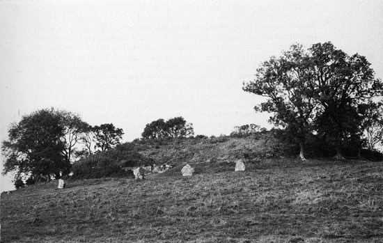
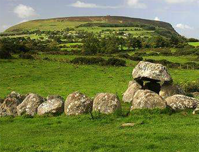
Look at the black and white photograph above. What do you see? A grass-covered knoll, with trees and other growth, with some big rocks scattered at the bottom. And that is about all people in Ireland saw for centuries, until over a lengthy period of investigation starting in the late 1960s and continuing now, scientists and archaeologists realized that this mound (Newgrange) and others like it contain the cultural maps of an ancient people. How ancient? Radiocarbon dating places them in the neolithic age, starting in the fifth millenium BC.
For the curious, who we are and where we come from may never be answered, and what we discover along our way can undo what we thought we knew. In 2013, my husband and I visited the giant mounds, or cairns, of County Meath where, 5500 years ago, settled communities chiseled their calendar into stone. The mounds are the oldest buildings in Europe still standing, and their engraved symbols are the subject of an intense renewed study.
Ireland is young. People have only lived there for about 10,000 years. While ice sheets on the European continent retreated north before paleolithic times, they didn't recede from Ireland until 8000 BC, when the earliest mesolithic migrants began making their way to areas all over the island—in the north, along the coast, and into the interior.
Some archaeologists believe the first migration was small, from Scotland, with settlers moving along the island's eastern shores, because of the similarities found in the mesolithic remains in both places. Peter Woodman, an Emeritus Professor of Archaeology at the Royal Irish Academy, has excavated sites in Coleraine, Northern Ireland, that date to 7900-7600 BC.
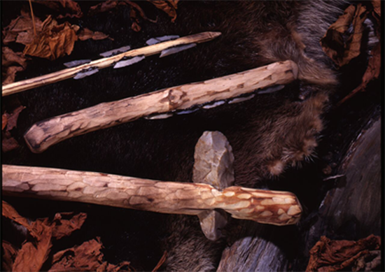
Other tools included flint and stone axes, picks, and borers.
© Ulster Museum, National Museums Northern Ireland. Used by permission.
Martin Brennan, an American researcher of megalithic stone engravings, notes in his book The Stones of Time the work of the Swedish archaeologist Goran Burenhult, who uncovered a mesolithic settlement dating to 7500 BC in Carrowmore, on the western edge of the island in present day County Sligo.
Evidence of other coastal and inland communities shows that mesolithic peoples populated much of ancient Ireland and that these people had "substantial material equipment" at their disposal, according to Brennan. The earliest comers took the animal-skin roofs of their timber-frame, igloo-shape homes with them from one settlement to another. They were fishermen, hunters, and gatherers, and the shores and forests of Ireland were full of fish, game, and berries. Archaeological findings show no evidence of weapons being used against other humans.
It is strange to think about life moving slowly for thousands of years. We don’t know what kind of hierarchies mesolithic family groups had, or how they conducted themselves vis à vis other groups. But they had connections with others along defined routes on the Irish island. They paved the way for those who followed, the neolithic people who settled the area permanently for a few thousand years starting about 4200 BC, among whom were the first astronomers to leave us their life's work.
Mesolithic Carrowmore was already a vital area; archaeologists have uncovered remains of communal structures there, and it became an early center of neolithic cairn building. According to Brennan and Burenhult, the cairns there precede those of Brú na Bóinne in County Meath by almost a thousand years. Brú na Bóinne, in turn, precedes the famous Stonehenge observatory in England by another 1000 years. With each new building venture, researchers say, came improvements in building efficiencies.
The Neolithic Engineers
of Brú na Bóinne
Photograph courtesy of Martin Byrne.
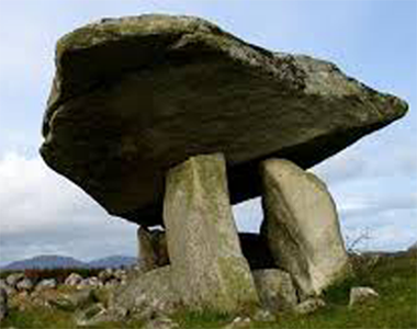
Who were these stone-workers, these forebears of ours? The stones stand where they have stood forever, stepped around by generations of sheep and sheep-herders, ignored in their ubiquity, carted off over the years for private fences and enclosures. Yet the sight of them is potent. I could not ignore them as I drove along the narrow roads of the Irish countryside, finding them everywhere I went—standing megaliths, dolmens, and rings of stone that predate our recorded history.
As we are now learning, these stone workers were astute observers of the skies and expert land surveyors; cairns throughout Ireland are aligned with solar and lunar events. As the astronomer builders developed their science over the centuries, they aligned their mounds with the solstices and equinoxes, lunar variations, and the stars.
Daily life was routine and sustaining enough to support, over more than 2500 years, non-subsistence activities such as the creation of art and symbolic language, ongoing astronomical observation, extensive land surveyance, the movement and positioning of insanely large, heavy megaliths, and the construction of the passage cairns.
The astronomical and cosmological symbols chiseled into the rock are a coded language (like other scientific codes) used to compute time and the lengthening and shortening of days. The mounds were observatories and educational centers that produced the first calendars we know of to appear in Europe.
The cairn builders didn't have the machinery that we have, but they had the same brains. They may have preceded us by five or six thousand years, which seems an eternity, but in the history of the human species it's a short time. Their earth-centered universe, which grounded them and gave them a workable cosmology, was a remarkable achievement that wasn't really refuted in the West until the sixteenth century, when Copernicus placed the sun at the center of the universe and Giordano Bruno, building on this, proposed that the universe was infinite and might have no center. And it was only in the seventeenth century that the revolution brought on by Tycho, Kepler, and Galileo introduced empirical data supporting their ideas. We aren't so far removed from these ancients, after all.
(Tycho's by-eye data almost died with him in 1601, but Kepler used Tycho's work to show that the planets move in elliptical—stretched out—orbits with the sun at one focus. And I must note that Aristarchus of Samos (310–230 BC), a Greek astronomer and mathematician whose ideas were rejected, also believed the universe was heliocentric, based on his correct observation that the stars had no observable movement, or parallax, relative to each other—something that could only have been proven with a telescope. And now modern cosmology brings us endless galaxies, time that moves relatively, and quantum mechanics, with an expectation of potential unknowable realities. We are in fact in a new era of astronomical discovery.)
The Palace
on the Boyne
The World Heritage Ireland website states:
Brú na Bóinne, which means the “palace” or the “mansion” of the Boyne, refers to the area within the bend of the River Boyne which contains one of the world’s most important prehistoric landscapes. (www.worldheritageireland.ie/bru-na-boinne/)
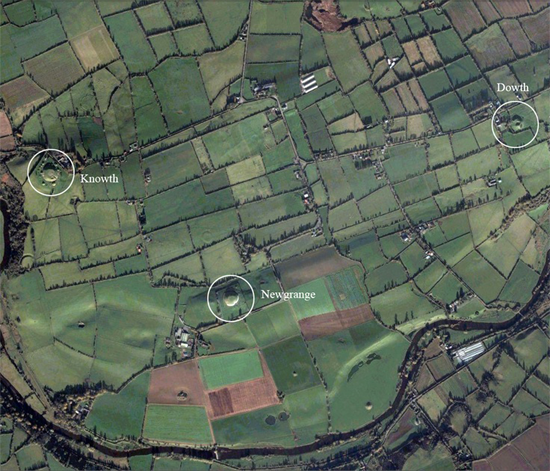
The photo below from the Irish World Heritage site is an aerial view of the Boyne River bend showing the Knowth, Newgrange, and Dowth mounds in relation to one another. Their distinct visibility from the sky is impressive. Their height was vital to their use as sundials across the landscape.
© Unesco World Heritage Site.
The bend in the Boyne, as it flows to the Irish Sea, is like a pair of protective outstretched arms embracing a people’s special place. The three great cairns in the bend, each with its group of smaller satellite mounds, tell a story of cultural permanence, where the symbols chiseled into the rock educated generations of people in, among other things, astronomy, timekeeping, megalith transport and building, and proper farm, crop, and soil maintenance according to the seasons.
The UNESCO World Heritage video below, Brú na Bóinne—Archaeological Ensemble of the Bend of the Boyne, provides a short but good introduction to the site.
Brennan, who is also an expert on neolithic Mexican rock symbolism and cosmology, has said of the Newgrange cairn:
If we can visualise Newgrange as a scientific instrument for a moment, we can get a glimpse of what it actually is. ...[I]t is the world's oldest sundial and at the same time, the world's largest. It is the oldest scientific instrument in the world that is still functioning and it will continue to function for all conceivable time regardless of minor changes in the tilt of the earth's axis. (Martin Brennan, Executive Magazine, 1979)
The Stars in the Sky
Study of the skies may have preceded the formation of religious ideas, or may have been a search for them. The sheer amount and intensity of the chiseling of symbolic code into the stone shows a fixation on computation and on understanding time, space, and the cosmic framework that the builders were organizing for themselves and their descendants. They paved the way for the mound and ring builders of Great Britain, the Iberian peninsula, and parts of Northern Europe.
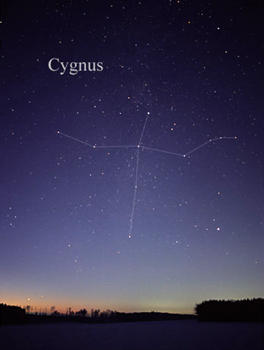
While we do not have access to spiritual ideas neolithic people might have derived from their study of the skies, we know they were sophisticated observers of the stars. The amateur astronomer Anthony Murphy has found that the shape and tilt of the inner Newgrange passage aligns with the constellation Cygnus, the Swan (see photograph, and Mr. Murphy's diagram below, which shows the five brightest stars in Cygnus).
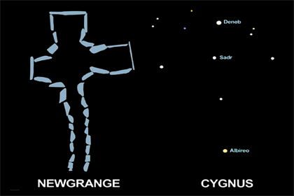
He has further found that the line of the winter solstice sunrise in the Newgrange passageway directly aligns with Four Knocks (Fuair Cnocs in Irish, the "Cold Hills"), a smaller mound complex nine miles away, and that Four Knocks directly aligned with Cygnus's bright star Deneb as it rose in the horizon in the neolithic era—even though Four Knocks is not visible from Newgrange.
In a YouTube video (below) that has an authenticity to it because it records an actual tour group, Mr. Murphy has other very interesting points to make about Newgrange. The earth's rotation axis is not fixed. The North Star, currently Polaris, changes based on where the earth's axis is pointing. The position of the equinoxes changes, very slowly, over a period of 26,000 years, in what is called precession. The constellation Cygnus was circumpolar (visible throughout the night) except during the 100 years it took to build Newgrange, when the bright star Deneb disappeared below the horizon and then rose in the place where Four Knocks points.
I discussed some of this by e-mail with a young astronomer friend of mine, Dr. Tim Pennucci of Columbia University in New York City (Tim has moved on to postdoctoral research in astrophysics at the Eötvös Loránd University in Budapest, Hungary.), who said:
The precession draws a circle on the sky, traced out by the Earth's spin axis, which is about 45 degrees across. That is, currently we point to the North Star [Polaris], but 13 thousand years ago, we pointed closer to the star Vega. Therefore, whenever people are talking accurately about these archaeoastronomical structures (or any phenomena having to do with the sky and structural alignment), they must take into account that the night sky looked quite different thousands of years ago than it does now. (Tim Pennucci, e-mail message 5/4/16)
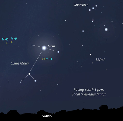
Mr. Murphy discusses some of this in his video. Sirius, in the constellation Canis Major across the southern sky, is our brightest star (other than our sun). Sirius was rising during the building of Newgrange and Murphy notes that its light was also visible from the chamber of Newgrange, and that the builders may have been using Sirius as a kind of precession device to study the slowly shifting positions of the stars. Within a few centuries Sirius was no longer shining through the aperture, and it looks as though the aperture was built to shut out "any stray light."
Murphy also brings up something I've wondered about, whether there is a second passageway aligned with the rear kerbstone at Newgrange that has yet to be excavated (Michael O'Kelly, the original excavator, never completed the excavation.).
The question about all of this, as Mr. Murphy asks in the video, is: how did they do it? They knew their geometry. Having chosen their spot, they probably laid out a cairn ring of stones, and then, working day and night, diagrammed the passageway and interior spaces on the ground, aligning them with whatever star constellation or celestial event they were tracking. For the "ceiling" and wall art to be correct, it too had to have been diagrammed beforehand. The building itself might have been considered a necessary protection of the knowledge contained therein.
There were probably only a few people who actually studied the heavens so intently. This was difficult work. There may have been a "class" in meso-/neolithic Ireland deemed to have the capacity for astronomical observation and the wherewithal to pass on their knowledge from one generation to the next. After all, how many Einsteins did we have in the twentieth century? One.
My friend Tim says that even the brightness of Sirius and Deneb are relative:
It's important to remember that many of the "bright" stars in the night sky are only apparently bright because of their proximity to us, and not because they are intrinsically bright. It's analogous to being a hundred yards from the stadium lights at a night game compared to having an ubiquitous 60-watt bulb shone right in your face. Both Deneb and Sirius are actually fairly bright stars intrinsically, but the latter is the brightest star in the night sky because it also happens to be quite close to us. (Tim Pennucci, e-mail message 5/6/16)
Besides being observatories, the cairns, with their interior art and special sections to house human remains, probably functioned as temples much like our own. Not many people were actually buried in them. Those who were may have been the learned, revered people who understood the astronomy and were thought to be mediators between the cosmic, or sacred, and the everyday. We'll never know for sure.
The video below streams photos I took at Knowth and Newgrange. A caveat: I made this video in 2013, just back from Ireland, without any of the information I later learned; I mistakenly call the cairns tombs and make some references to Celts that I now think are wrong, but it does give an immediate sense of my walkabout. The music in the video, Caoire Geala Bána (Bright White Sheep), was written by the contemporary Irish composer Peadar Ó Riada, who graciously allowed me to use his piece. The music is slow and sounds ancient to me, like it belongs to the stones.
Mapping the Sun's Rays
Neil L. Thomas, an Australian engineer whose book Irish Symbols of 3500 BC is a study of the Brú na Bóinne complex, explains the placement of the mounds:
The Knowth mound is north-west of Newgrange, directly aligned on a minor lunar standstill, north 56° west, and at a distance of 1.3 kilometers. The complementary Dowth mound is also on a minor lunar standstill alignment, this time north 59° east, and at a distance of two kilometers. Both mounds have passages with solar alignments. At Knowth, the two passages into the mound are aligned with sunrise and sunset at the equinox. A short passage into the Dowth mound is aligned with the midwinter sunset at solstice, complementing the sunrise passage on the same day at Newgrange. A second longer passage ... has an alignment of the calendrical quarter days in November and February.
...[A] number of other standing stones and earthenworks within the bend of the river provided a series of solar and lunar alignments, the totality of which shows the area was constructed according to a precise astronomical plan. (N.L. Thomas, p.18)
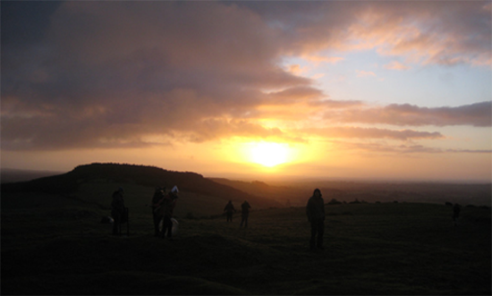
Once the winter solstice event occurs at sunrise at Newgrange, the mapping of the sun's journey is not over. The bright beam enters other, satellite cairns during the day, resting at a cairn called Cairn K at noon. At sunset, it makes its last appearance at the large cairn at Dowth. Thus, the whole of the sun's journey is charted on the shortest day of the year, when the sun is at its lowest arc across the sky and its shadows are at their longest. Farmers throughout the area, whose lives were tied to the seasons and harvest cycles, would depend on this information.
Knowth, built on an even larger scale, has a similar solar illumination at sunrise on the equinoxes, equivalent to our March 21 and September 21.
The Irish Times carried the following picture by photographer Alan Betson of the December 21, 2003 winter solstice at Newgrange on its front page the next day, December 22. The sun's beam through the aperture was especially brilliant as it lit up the passageway.

http://www.knowth.com/winter-solstice.htm
of p.131 of The Stones of Time.
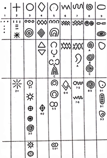
Martin Brennan gives the most complete study of the ancient code in his book The Stones of Time. Interspersed with his text, he provides his own drawn reproductions of the symbols on 203 of the 390 stones he has studied, along with his astronomical interpretations. He has put into table format the nine basic geometric shapes he considers "essential elements" of megalithic art, shown here. The numbered symbols in row 1 he calls the "primaries": dot, line, circle, quadrangle, arc or crescent, zigzag, wavy line, spiral, and oval or ellipse. Row 2 shows the principal ways in which the primaries combine to form sets. Each variant of a shape, for example the A, B, or C type of the crescent shape under column 5, is distinct, as is each combination of shapes. Circles and crescents are dominant, showing a "pre-occupation with the sun and moon that is evident in the structure of the mounds." (Brennan, p.132)
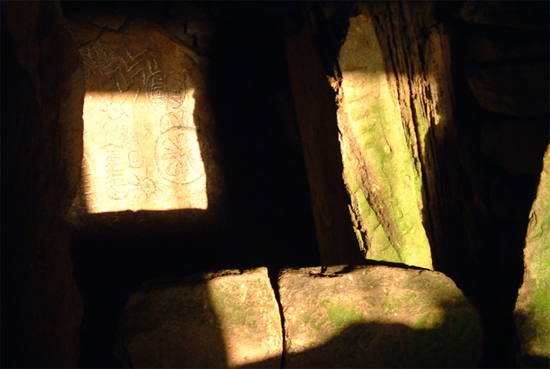
Mr. Brennan's book has dramatic black and white photographs interspersed throughout of the moving beams of light, at various times of day, at various cairn locations. The photographs are haunting in their non-glossy simplicity and focus.
One sequence of photos on page 100 maps the September 22, 1980 autumnal equinox on Cairn T at Loughcrew, a mound complex also in County Meath built 500 years earlier than Knowth. At 7:11 a.m., reports Brennan, the beam of light starts streaming into the passage, hitting the backstone at 7:46 a.m. It moves across that stone a rate of 1 minute 12 seconds per inch (a journey of 29 minutes). From its start on the backstone, the beam takes 1 hour 18 minutes to disappear on stone 6. This striking sequence of photos of the moving light shows the observatory still working today as it was built to do 5700 years ago.
Photograph courtesy of Clare Tuffy, Manager, Brú na Bóinne Visitors Center
When I check myself, when I wonder whether in 2016 we are ascribing false meaning to the cairns of prehistoric times, when I tell myself we really have no idea what these ancient people were doing—I then perform a recheck. Maybe we should move back the date for when our historical era started. The cairn builders weren't great astronomers within a culture where people otherwise went grunting about their fields.
They had too much to lose if they didn't make sense of their world, and what they gained was their humanity. We weren't left with a record of their language. They didn't live in a place where soft clay or papyrus allowed for a less strenuous transcript of code; I can only imagine how hard was the work of chiseling the rock, much less transporting it. It is likely that they used tree bark and logs to record certain information. Learning was likely memorized (maybe even sung, for easier memorization), an art all but lost to us now.
In fact, after studying some of the symbols as decoded, separately and at different times, by Martin Brennan, Neil Thomas, and others, the carvings look much less mysterious. The equations of modern physics, or the weirdness of computer programming code, can look like gobbledegook to an untrained eye, but they are tools of the trade to those who study (and create) them. It's not so different with the ancient code.
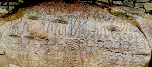
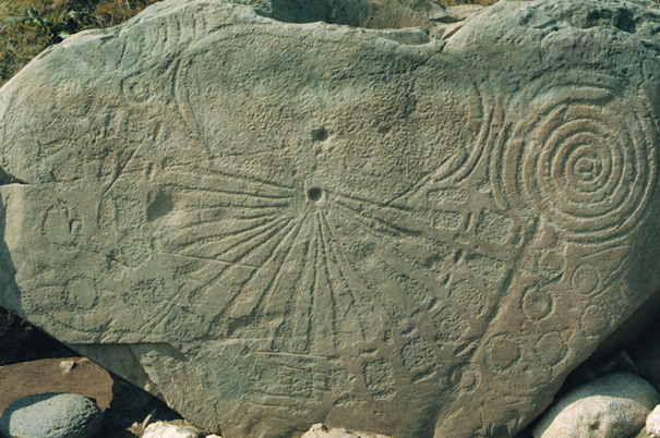
Knowth—The Sundial Stone
Three figures are shown below: a stone with carvings, a labeled drawing of the stone by Neil L. Thomas, and two labeled drawings of the stone by Martin Brennan. Thus we have the stone and some interpretations of its symbols: the Knowth sundial stone, also called the solar stone or calendar stone. The stone's three rightmost engravings are cut off from the photo below but are represented in the drawings. (There are similar stones; Loughcrew has a less delineated sundial stone that perhaps was the forerunner of the Knowth stone.)
The Knowth complex is known for its calendrical engravings (such as K53 above). The early astronomers synchronized the Metonic and synodic lunar cycles with the solar year. I cannot give here a mathematical explanation of the moon's 19-year cycle, which returns it to exactly the same place, same longitude, and aligned with the same constellation from which it started (a full explanation is available on the Internet), but the neolithic astronomers in Ireland understood these alignments and synchronies, and we're only beginning to fathom how deep their knowledge was.
Heritage & Local Government, Ireland.
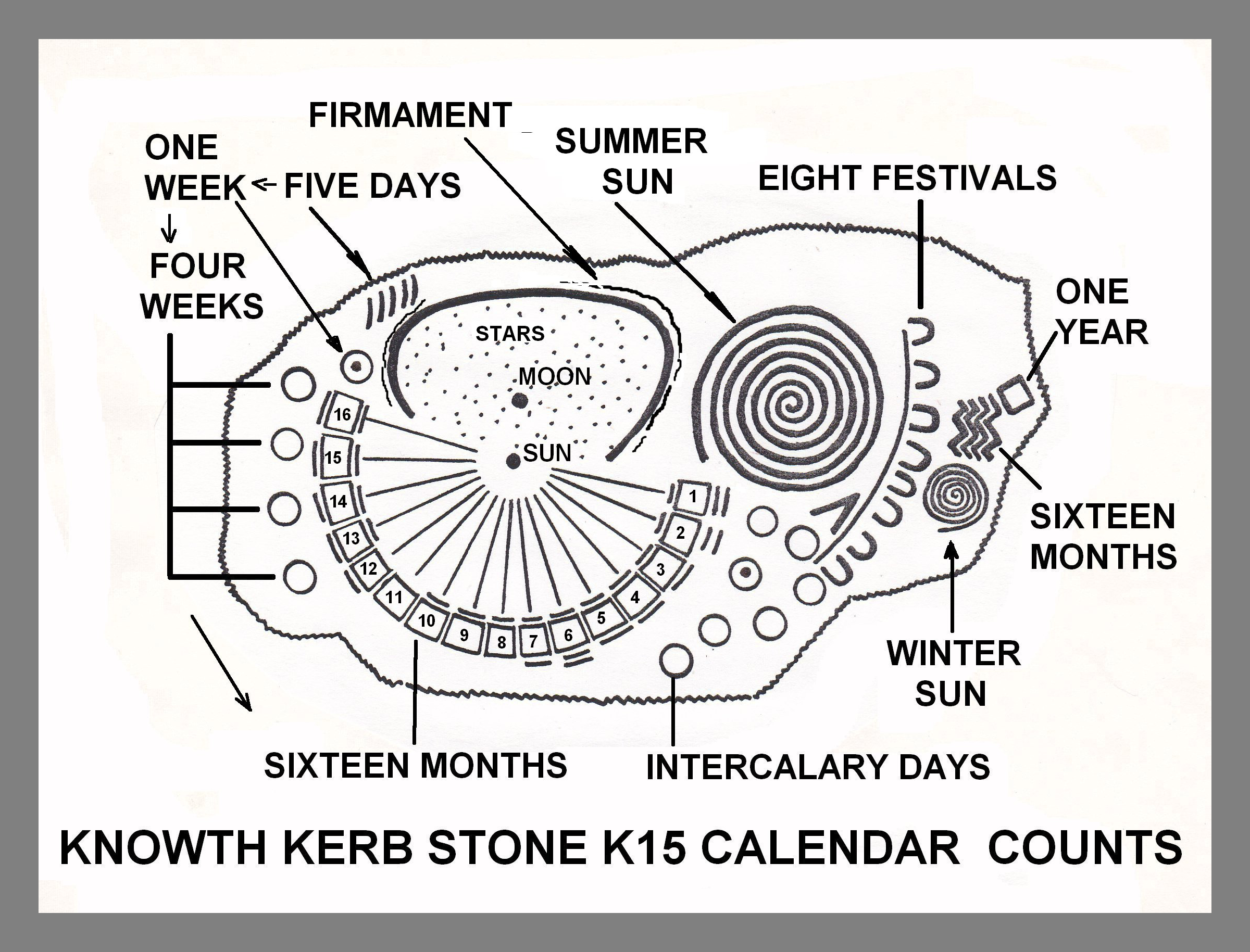
This sundial stone has an almost modern look to me, a kind-of stone text used to teach the students who would be responsible for maintaining and circulating the information. Perhaps this was one of its functions. Mr. Brennan has named this stone SE4 with respect to its southeast alignment at the mound; it is also known as K15 with respect to its numeric placement around the base of the mound.
Thomas's focus is on the stone's calendrical symbols. The yearly calendar of 16 months is arrayed at the ends of the rays in the semicircle. The small, linear grooves above and below each month represent the number of days added to each particular month to fill out the 365-day year, with the original count starting at 21 (thus, e.g., the first month has 21 plus 3, or 24 days). Month 11 has no groove because it has only 21 days.
Courtesy of Neil L. Thomas.
The right-side set of 4 zigzags, each with four points, represent the four seasons (each with four months); the point of a zigzag (up, down, left, or right) is always a count of one. The square to the right of the zigzags is one complete year; a square represents a completed cycle, or whole. The brighter, warmer summer sun on the top right, with its counter-clockwise, looser rings (longer days), is larger than the tightened, clockwise rings (shorter days) of the winter sun on the lower right. The eight festivals Thomas labels are the two solstices, the two equinoxes, and the four quarter days falling between them (our August 1, November 1, February 1, and May 1).
The arc or crescent at the top of the stone outlines the heavenly firmament. It is the vault of the heavens overhead, holding together the sun, the moon, and the stars. On the stone, the sun is the most deeply incised symbol. The moon is also deeply incised, and the stars are represented as picked markings in the heavenly vault.
Brennan's diagrams focus on the gnomons. The gnomon is the triangular part of a sundial that casts the shadow. Diagram 1 shows "the extreme annual positions of the sun's shadows cast from the upper gnomon." Diagram 2 shows the positions at midday.
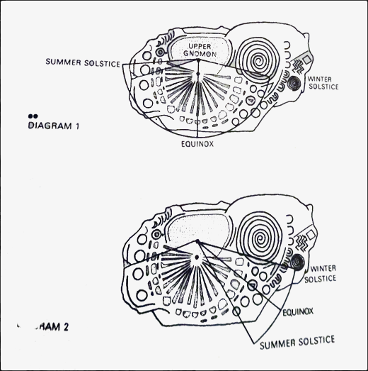
Brennan says:
The sun casts its shadow on the spiral indicating the beginning and end of a solar year at winter solstice. The left-handed winding of the spiral is matched to the anti-clockwise double-spiral year shape at winter. The shadow continually returns to the spiral and emerges from it at the turning of the year. Units of the radial emanate from the spiral in much the same way that lunar crescents emerge from the spiral on SW22. (Brennan, p.190)
To show that this stone was used as a sundial, with its gnomon positions and radial angles clearly marked, Brennan constructed an exact model of the stone. Brennan and his colleagues collected data every day for a full year. Not only is the stone a functioning sundial, said Brennan, but it is a
highly sophisticated sundial utilising multiple gnomons and functioning every day of the year. Technically, it would be classified as a vertical east-declining dial. Position of the sun at equinox and summer solstice are particularly heavily inscribed. The astronomical data that the sundial is capable of registering far exceeds agricultural requirements and is more in the area of precision timekeeping. (M. Brennan, letter 9/19/1980 to The Irish Times, www.newgrange.eu/stonelight51a.htm)
After looking at the symbols above, Tim Pennucci wrote to me,
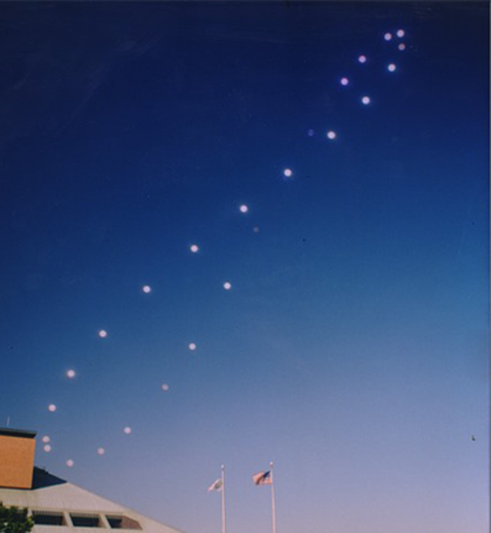
The spiral shapes I also thought were interesting, especially the joined double-spiral, which (to me) is reminiscent of the annual analemma pattern of the sun in the sky. These people could have been able to to map this kind of pattern, and since the directionality of the sun's motion on the sky changes near the equinoxes, it could be represented by spirals (but not quite a "winter" or "summer" sun interpretation). (Tim Pennucci, e-mail message 5/10/16)
An analemma is a diagram plotting the position of the sun from a fixed position on earth at the same time every day for a year. The resulting curve is an elongated figure eight, as shown in the photograph below.
Who Were These Astronomers?
Theories abound about the origins of the neolithic astronomers and the mesolithic tribes who preceded them. They weren't Celts, but maybe they were proto-Celts. It is interesting that the later pagan Irish religion and myths centered in large part around the mounds, and that their art so resembled the abstract art characteristic of the cairn builders.
One theory I don't like is that these astronomers were from outer space—yes, that they were a celestial race. Both neolithic and ancient Irish culture are dead, and it is easy and I suppose satisfying to create fanciful stories, and this is one of them.
The "celestial race" theory denies the achievement of these ancient astronomers. We must give credit where credit is due. Anthony Murphy in his YouTube video (link above) said that using Google earth, we can see how perfectly aligned the astronomical sites across Ireland are, with each other and with the heavenly movements as they were perceived from earth. Maybe the builders did believe they were following the wishes of the denizens of the heavenly vault (sun, moon, and star gods), but even if this is true, it was human intelligence, perseverance, and labor that built the observatories.
The early builders perfected the art of megalith log-rolling (transporting the megaliths on logs they forested). They also knew how to position and raise the megaliths. This required not simple strength, but training, commitment, and cooperation. They could do all this because they had a developed communal life with cultural connections to other villages. They transported livestock and grain by boat and were expert sea travelers. Their success with farming, building, and culture creation must have been its own incentive to maintain their way of life. And they pretty much had the place to themselves. The time intervals of between 100 to 500 years for each new observatory, over about 2500 years, is evidence of a long-term cultural success story.
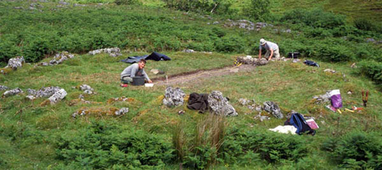
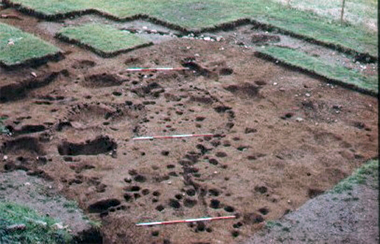
A 2003 excavation of the flat plateau of Doonaveeragh Mountain, County Sligo.
The photograph above is an excavation of one of the largest and oldest known neolithic villages in Ireland, on the plateau of Doonaveeragh Mountain in County Sligo. Martin Byrne's website notes there were 180 circles of various sizes, and several other enclosures, as well as several springs just below the eastern edge of Mullaghafarna, and that further down, crossed by a stone wall, are the shattered remains of a large court type monument.
But Where Did They Come From?
This is a fine question in light of the fact that no people inhabited Ireland much before 8000 BC. Neil Thomas, who mentions in his book that he started his work out of curiosity about his Celtic roots, has found that the calendar of the cairn building astronomers has similarities with the calendar of the people of northwest Europe. The five-day week and sixteen-month year were also the basis of the Norweigan calendar.
Thomas has posited that the Norse gods for whom the five-day week is named—Sun day, Moon day, Woden's day, Thor's day, and Freya's day—had some basis in a prehistoric religion shared by Irish meso-/neolithic settlers in a more distant time. The first migrants on the island's northeast shore likely shared genes with the sea-going people of the far north.
Thomas also notes that the five-day week found in the Mount Pleasant Sanctuary, Woodhenge, and Stonehenge calendars of Great Britain (c.2500-2000 BC), all built after the Brú na Bóinne buildings, match the Irish calendar point by point. He has found that the chiseled symbols in the British sites function the same as those in Ireland.
On December 28, 2015, in the British publication The Guardian, Tim Radford, a freelance journalist and founding editor of the Climate News Network website, reported on an interesting scientific study. Geneticists from Trinity College Dublin, and archaeologists from Queens University Belfast, performed DNA testing on four skeletal remains, one of a woman unearthed from a tomb in an ancient farming site in Ballynahatty, near Belfast, that was 5200 years old, and three of men found on Rathlin Island in County Antrim that were about 4200 years old.
Their ages put them squarely in the neolithic, cairn-building era. The woman's DNA was unmistakably Middle Eastern. People from the Middle East traveled by sea across the Mediterranean, through the Strait of Gibralter and up the Atlantic to coastal Ireland, and their closest genetic relatives now live in Sardegna (the island of Sardinia in Italy). The ancient inhabitants of Africa's northern coast and the Levant were intrepid sailors who navigated an Atlantic route using the North Star as their compass.
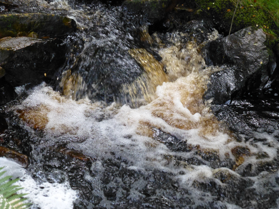
The DNA of the later, male skeletons originated in what is now the Ukrainian steppe, which borders on the Black Sea. These migrants were gifted metallurgists. They may have traveled to Ireland through central and southern Europe, but more likely, being sea people, they traveled through the Strait of Bosphorus and took the Atlantic route similar to that of earlier migrants, first arriving about 4300 years ago. Their DNA matches present-day populations of modern Ireland, Scotland, and Wales. There was plenty of copper in Ireland for these workers—see the photograph below that I took of copper in the water in County Donegal.
Photograph © Frances Stevens.
After my trips to Ireland, before I knew any of this, I would always say that the Irish have a couple of different looks, but they all "walk Irish," a bounce in the step. Wherever their DNA comes from, they are more alike than different. The scientists who performed the DNA study noted a pattern of migration:
... of stone age settlers with origins in the Fertile Crescent, and bronze age economic migrants who began a journey somewhere in eastern Europe.
...
Migrant communities did not compete with the original Irish. They became the Irish. (www.theguardian.com/science/2015/dec/28/. Emphasis mine.)
The isle's relative remoteness and infrequent migrations in the meso-/neolithic eras, along with the particular talents and gifts the migrant groups brought with them, helped produce its stability and productiveness. Each migrant wave built on what it found there, and "became Irish."
In the historical era, the tenth century Viking invaders also stayed and "became Irish," adopting the Irish language and turning Dublin into a major mercantile and trading center in medieval Europe.
After I wrote the above, a reader told me about a book by a Connemara man named Bob Quinn called The Atlantean Irish (see Reader's Page). Quinn's book is not solely about the mesolithic and neolithic eras, but he builds a wonderful argument for Irish continuity through several millennia based on the island's seafaring people and their connections along a well-used Atlantic route with the seafaring peoples of coastal western Norway/Iceland and coastal north Africa/the Levant. Quinn describes Ireland, especially its west coast, as a prime meeting, trading, and migration center. He quotes from a study done by a team of geneticists from Trinity College, Dublin, of mitochondrial DNA testing, published in the October 2004 American Journal of Human Genetics. The study showed that the "Celtic" people of Ireland, Scotland, Wales, and Brittany share (emphasis is Quinn's):
multiple genetic marker systems [that] indicate a shared ancestry throughout the Atlantic zone, from northern Iberia to western Scandinavia, that dates back to the end of the last Ice Age. (Quinn,p.132, citing AJHG).
References & Works Cited
Martin Brennan, "Cracking the Newgrange Code,"Executive Magazine, 1979.
_____, The Stones of Time (Inner Traditions International, 1994) (originally published by Thames & Hudson, 1983).
Brú na Bóinne (Archaeology Ireland, 2003).
Martin Byrne, The Sacred Island (2016).
Knowth site map (2016).
Anthony Murphy, Mythical Ireland (2016).
Tim Pennucci, discussions via email, May 4–9, 2016.
Bob Quinn, The Atlantean Irish (The Lilliput Press, 2004).
Tim Radford, Irish DNA originated in Middle East and eastern Europe
Neil L. Thomas, Irish Symbols of 3500 BC (Mercier Press, 1988).
Comments? Please send your responses
on the site's Contact page.Thank you!